1. Introduction & Overview
What is SLAM?
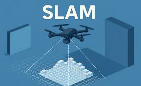
Simultaneous Localization and Mapping (SLAM) is a computational technique that allows a robot (or autonomous system) to build a map of an unknown environment while simultaneously determining its own position within that map.
This is a fundamental capability for autonomous navigation in robotics, self-driving cars, drones, and industrial automation.
History & Background
- 1986: The concept of SLAM was formally introduced in mobile robotics research.
- 1990s: Probabilistic approaches (e.g., Kalman filters, particle filters) became standard.
- 2000s: Advances in computer vision introduced Visual SLAM (V-SLAM) using camera sensors.
- 2010s onward: Real-time SLAM powered by GPU acceleration and cloud-based processing emerged.
- Today: SLAM is deeply integrated into RobotOps pipelines for navigation, automation, and real-world robotics deployments.
Why is SLAM relevant in RobotOps?
In RobotOps (Robotics Operations), SLAM plays a crucial role by enabling:
- Autonomous deployment: Robots can explore unknown facilities without preloaded maps.
- Continuous monitoring: SLAM ensures position accuracy for inspection robots.
- Cloud-RobotOps integration: Maps can be shared across fleets for collaborative navigation.
- CI/CD for robotics: SLAM algorithms are tested, validated, and deployed automatically in ops pipelines.
2. Core Concepts & Terminology
| Term | Definition | Example in RobotOps |
|---|---|---|
| Localization | Estimating the robot’s position and orientation in an environment | A warehouse robot locating itself between shelves |
| Mapping | Building a map of surroundings using sensors (LIDAR, camera, sonar) | Creating a floor map of a factory |
| Odometry | Motion estimation using wheel encoders or IMU | Dead reckoning in mobile robots |
| Loop Closure | Recognizing previously visited places to correct drift in mapping | A robot re-identifying the factory entrance |
| Sensor Fusion | Combining multiple sensors for accuracy | LIDAR + Camera + GPS integration |
| V-SLAM | Visual SLAM using cameras instead of LIDAR | Drone navigation using onboard camera |
Fit into the RobotOps Lifecycle
- Development: SLAM algorithms are designed, simulated, and tested in frameworks like ROS (Robot Operating System).
- CI/CD Pipelines: Automated testing of SLAM under different environments before deployment.
- Deployment: Robots use SLAM in real environments with continuous monitoring.
- Ops Monitoring: Logs, metrics, and telemetry from SLAM are fed back to improve models.
3. Architecture & How It Works
Core Components
- Sensors – LIDAR, cameras, IMU, GPS
- Front-End Processing – Feature extraction, sensor data processing
- Back-End Processing – Optimization, loop closure, global consistency
- Map Representation – Occupancy grids, point clouds, semantic maps
- Localization Engine – Real-time position estimation
- Ops Integration Layer – Cloud sync, monitoring, CI/CD validation
Workflow
- Robot senses the environment → collects raw sensor data.
- Front-end extracts features (edges, landmarks, points).
- Back-end applies optimization (graph-based SLAM, EKF-SLAM).
- Map updated in real-time.
- Robot localizes itself using map feedback.
- Data pushed to cloud/RobotOps monitoring pipelines.
Architecture Diagram (textual representation)
[ Sensors: LIDAR, Camera, IMU ]
          ↓
 [ Front-End Processing: Feature Extraction ]
          ↓
 [ Back-End Optimization: Loop Closure, Graph SLAM ]
          ↓
 [ Map Representation: Occupancy Grid / Point Cloud ]
          ↓
 [ Localization Engine ]
          ↓
 [ RobotOps Layer: CI/CD, Cloud Integration, Monitoring ]
Integration Points with CI/CD or Cloud Tools
- GitHub Actions / GitLab CI → Automated SLAM simulations (Gazebo, RViz).
- Kubernetes → Deploy SLAM microservices (map storage, real-time localization).
- AWS RoboMaker / Azure Robotics → Cloud-based SLAM training and map distribution.
- Monitoring → Prometheus/Grafana for SLAM telemetry (latency, accuracy).
4. Installation & Getting Started
Prerequisites
- Ubuntu 20.04 or later
- ROS (Robot Operating System) installed
- Python 3.8+
- A robot simulator (Gazebo) or hardware (TurtleBot, DJI Drone, etc.)
Hands-On: Basic Setup (Example: ORB-SLAM2 with ROS)
# 1. Install ROS dependencies
sudo apt update && sudo apt install ros-noetic-desktop-full

# 2. Clone ORB-SLAM2
cd ~/catkin_ws/src
git clone https://github.com/raulmur/ORB_SLAM2.git

# 3. Build the package
cd ~/catkin_ws
catkin_make

# 4. Run demo with camera feed
roslaunch ORB_SLAM2 RGBD.launch
The robot will now build a real-time 3D map from the camera feed.
5. Real-World Use Cases
- Warehouse Automation
- Robots use SLAM to navigate shelves, pick items, and optimize delivery routes.
- Autonomous Vehicles
- Self-driving cars rely on SLAM to localize themselves in GPS-denied environments (e.g., tunnels).
- Healthcare Robots
- Hospital robots delivering medicines/navigating corridors use SLAM for accuracy.
- Agriculture & Drones
- Drones performing crop surveys build maps of large farmlands with SLAM.
6. Benefits & Limitations
Benefits
- Works in unknown environments (no prior map needed).
- Enables real-time navigation.
- Sensor-agnostic (works with LIDAR, cameras, IMUs).
- Scales from indoor robots to autonomous cars.
Limitations
- High compute requirements for real-time SLAM.
- Sensor noise can degrade performance.
- Struggles in featureless environments (e.g., empty halls).
- Requires robust loop closure detection to prevent map drift.
7. Best Practices & Recommendations
- Sensor Calibration: Regularly calibrate LIDAR/cameras to reduce drift.
- Simulation First: Test SLAM algorithms in Gazebo before deployment.
- Performance Tuning: Use GPU acceleration for large-scale maps.
- Security: Encrypt telemetry sent from robots to cloud.
- Compliance: Align SLAM data handling with GDPR/ISO safety standards.
- Automation: Automate regression tests for SLAM in CI/CD pipelines.
8. Comparison with Alternatives
| Approach | Key Feature | When to Use |
|---|---|---|
| SLAM | Builds map + localization simultaneously | Unknown environments |
| Localization-only | Assumes a pre-built map | Fixed environments (factories) |
| GPS-based Navigation | Uses satellite positioning | Outdoor environments with GPS coverage |
| Beacon-based | Uses RF beacons or UWB anchors | Indoor positioning where SLAM is computationally heavy |
Choose SLAM when environments are dynamic, unknown, or unmapped.
9. Conclusion
- SLAM is a cornerstone of RobotOps—it enables autonomous navigation in unknown environments while fitting seamlessly into DevOps-style robotics pipelines.
- Future trends: Cloud-based SLAM, multi-robot collaborative SLAM, and AI-enhanced SLAM (using deep learning for feature extraction).
- Next Steps:
- Explore ROS tutorials on SLAM (http://wiki.ros.org/slam_gmapping)
- Join communities like ROS Discourse or OpenSLAM.org
- Experiment with ORB-SLAM2, Cartographer (Google), or RTAB-Map.
